Pointe du Hoc: The Complete D-Day Visitor Guide for 2026

Pointe du Hoc is a 30-metre clifftop promontory on the Normandy coast, roughly midway between Utah Beach and Omaha Beach, and the site of one of the single most audacious actions of D-Day: the US Rangers’ cliff assault of 6 June 1944. Sometimes misspelled “Point du Hoc” or, in older American military records, “Pointe du Hoe,” this small headland was judged important enough to be assigned its own dedicated Ranger force, separate from the beach landings either side of it. Pointe du Hoc is around 57km from Caen and roughly 67km from the Portsmouth to Caen ferry terminal at Ouistreham — easily combined with Omaha Beach, around 10.5km (6.5 miles) to the east, or Utah Beach, around 21km to the west.

Pointe du Hoc WW2 history centres on a single, extraordinary mission: before dawn on D-Day, US Army planners believed a battery of German 155mm guns sat on this clifftop, capable of hitting both Utah and Omaha beaches. Destroying them was handed to the 2nd Ranger Battalion under Lieutenant Colonel James Earl Rudder, who led roughly 225 men in scaling a sheer 100-foot rock face under direct enemy fire using ropes, ladders and rocket-fired grappling hooks — one of the most dangerous single objectives assigned to any unit on D-Day.

This complete guide to Pointe du Hoc covers everything you need to plan your 2026 visit: the full story of what happened here on D-Day, why the site mattered so much to Allied planners, the casualty figures behind the Rangers’ cliff assault, what the name Pointe du Hoc actually means, and a practical guide to visiting today — including the ongoing preservation works currently affecting parts of the site.

Last updated: July 2026 | Facts verified from the American Battle Monuments Commission, the US Army’s official history, Britannica, Normandy Tourism and primary sources.
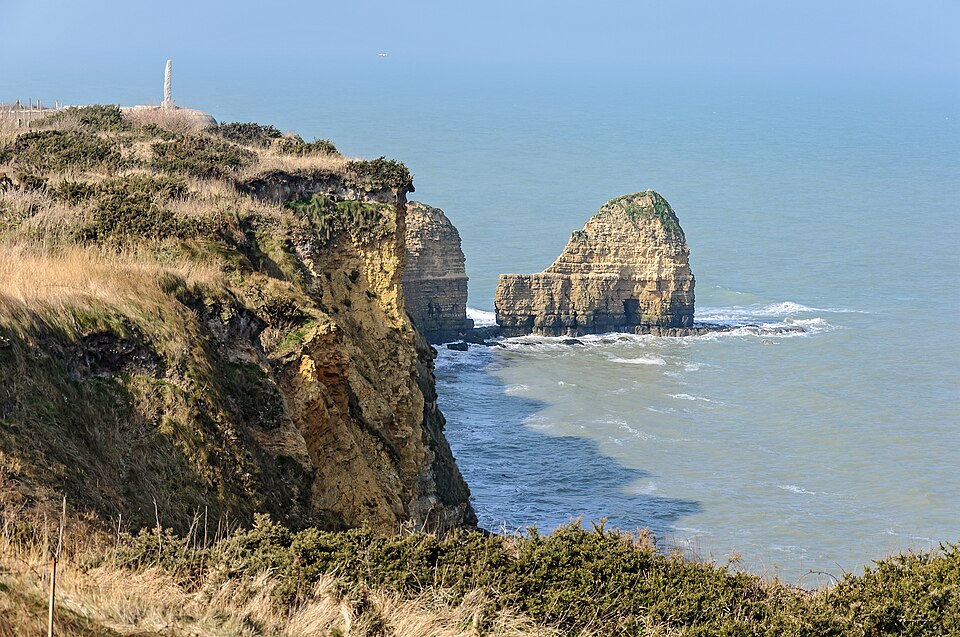
Pointe du Hoc Normandy Cliffs.

Pointe du Hoc — Key Facts for 2026

57km from Caen · Between Utah & Omaha Beaches · Assault began ~07:10, 6 June 1944 · 2nd Ranger Battalion · ~225 Rangers landed · 77 killed and 152 wounded over two days of fighting

Check Ferry Prices & Book Portsmouth to Caen →

🇺🇸 Pointe du Hoc at a Glance

30m
The height of the cliffs the Rangers scaled — around 100 feet
FREE
Site access and the visitor centre, year-round
07:10
Rangers land, roughly 40 minutes behind schedule
~60%
Casualty rate among the Rangers who scaled the cliffs
  • The battlefield itself — preserved in a deliberately “battle-scarred” state since 1944: bomb craters, shattered casemates and trenches, largely untouched. Free, open access
  • Pointe du Hoc Ranger Monument — the granite dagger memorial atop the German observation bunker, at the very tip of the promontory. Free, always accessible
  • Visitor Centre — run by the American Battle Monuments Commission, with exhibits on the Ranger assault. Free, open daily
  • German gun casemates & bunkers — several concrete positions still stand, some still under construction when the Rangers attacked. Free, open access
  • ⚠️Preservation works 2026–mid 2027. Site-wide safety and erosion-protection works are under way. Pointe du Hoc remains open throughout, but some paths and viewpoints are temporarily adapted or restricted — see the Top Tips section below

What Happened at Pointe du Hoc on D-Day

By early 1944, Allied intelligence had identified a German battery of six First World War-vintage French 155mm howitzers on the clifftop at Pointe du Hoc, with a range of up to 25km — enough to reach both Utah and Omaha beaches. General Omar Bradley called neutralising it “the most dangerous mission of D-Day,” and handed the job to the specially trained 2nd Ranger Battalion.

The US Rangers’ D-Day Cliff Assault

Naval bombardment of Pointe du Hoc began at 05:50, including the battleship USS Texas, following an RAF raid earlier that night that had dropped some 635 tons of bombs on the position. Lieutenant Colonel James Earl Rudder’s plan called for roughly 225 men of Companies D, E and F, 2nd Ranger Battalion, to land directly beneath the cliffs and scale them using ropes, extension ladders and rocket-propelled grappling hooks fired from the landing craft. A navigation error sent the flotilla off course, and by the time Rudder corrected it and the Rangers touched down, they were roughly 40 minutes behind schedule — landing at around 07:10 instead of the planned 06:30. The delay meant the covering naval bombardment had already lifted, giving the German defenders time to man their positions along the cliff edge.

Under direct machine-gun and grenade fire from above, the Rangers began their climb. Ropes were cut by German defenders; some men climbed using only their hands, knives and whatever handholds the shattered cliff face offered. Within roughly 30 minutes, the first Rangers had reached the top. What they found waiting for them changed the mission entirely.

The Guns Were Gone — and Then They Weren’t

Reaching the German gun casemates, the Rangers found them empty. Unknown to Allied planners, the six guns had been withdrawn inland weeks earlier for protection from the bombing campaign, and dummy wooden poles had been left in their place to fool aerial reconnaissance — only four of the concrete casemates had even been completed by 6 June. Rather than declare the mission accomplished, a small patrol led by First Sergeant Leonard “Len” Lomell and Staff Sergeant Jack Kuhn pushed south, past a burning farmhouse, and discovered the actual guns hidden in a sunken country lane, camouflaged but unguarded and ready to fire on Utah Beach. Using thermite grenades, Lomell and Kuhn disabled the sights and breech mechanisms of five of the guns before German patrols forced them to withdraw — destroying the entire battery without a single shot fired from the guns themselves.

With the primary objective achieved by around 09:00, the Rangers dug in on the clifftop and established a defensive perimeter across the coast road, cutting off a key German route to the beaches. For the next two days, this small, isolated force held its position against repeated German counterattacks — cut off from reinforcement, uncertain whether the wider invasion had even succeeded, and steadily worn down. They were finally relieved on the morning of 8 June, when tanks of the 743rd Tank Battalion and Rangers of the 5th Battalion fought their way through from Omaha Beach.

🎖️ “Rangers, Lead the Way”

Because Rudder’s force was delayed reaching Pointe du Hoc, the follow-on Rangers of the 5th Battalion and two more companies of the 2nd, waiting offshore for a signal that never came in time, were redirected to Omaha Beach instead — landing at the Vierville draw and helping break open one of the most heavily defended sectors of that beach. It’s from this moment that the motto “Rangers, lead the way” is traditionally traced, later adopted formally by the US Army Rangers.

💣 A Moonscape by Design

Some historians estimate Pointe du Hoc absorbed more than ten kilotons of high explosives in the weeks and hours before and during the invasion — roughly comparable in scale to the atomic bomb dropped on Hiroshima, though delivered gradually rather than in a single blast. The result is the huge, moon-like cratered landscape still visible today, some craters over 9 metres deep and 15 metres across.

🎙️ Reagan’s “Boys of Pointe du Hoc”

On the 40th anniversary of D-Day in 1984, US President Ronald Reagan delivered one of the most famous speeches of his presidency at the Ranger Monument, addressing the surviving veterans directly: “These are the boys of Pointe du Hoc.” Sixty-two of the original Rangers who had climbed the cliffs were present to hear it, standing on the ground where so many of their comrades had fallen forty years earlier.

Who Fought at Pointe du Hoc?

Unlike the five main landing beaches, Pointe du Hoc was a single, tightly-defined objective assigned to one specialist force — though its outcome was shaped just as much by the men who never made it there.

🇺🇸 2nd Ranger Battalion — Force A

Command: Lieutenant Colonel James Earl Rudder, a former Texas A&M football coach commanding his first combat operation.

Assault force (roughly 225 men):

  • Company D — landed on the western side of the point
  • Companies E & F — landed on the eastern side
  • 12-man naval fire-control party, with a forward observer from the 58th Armored Field Artillery Battalion

Naval support: the destroyer USS Satterlee and battleship USS Texas provided close fire support throughout the assault and the two-day defence that followed.

🎖️ Force B & Force C — Diverted to Omaha

Company C, 2nd Ranger Battalion (Force B) landed separately at Omaha Beach’s Charlie sector. Lieutenant Colonel Max Schneider’s follow-on force — Companies A and B of the 2nd Battalion plus the entire 5th Ranger Battalion (Force C) — waited offshore for Rudder’s success signal, which never arrived in time, and was redirected to Omaha’s Dog Green sector instead, reinforcing the hard-fought landing there.

A relief column of the 5th Ranger Battalion and tanks of the 743rd Tank Battalion fought overland from Omaha to finally reach Rudder’s men at Pointe du Hoc on the morning of 8 June.

The German Defenders at Pointe du Hoc

The battery itself belonged to the 2nd Battery, Heeres-Küsten-Artillerie-Abteilung 1260 (Army Coastal Artillery Battalion 1260), while infantry protection along the clifftop and the coast between Grandcamp and Vierville came from the 3rd Battalion, Grenadier-Regiment 726, part of the German 716th Infantry Division. By D-Day, the position’s guns had already been relocated inland for their own protection, replaced by unarmed wooden decoys — meaning the Rangers who scaled the cliffs faced determined infantry defenders and machine-gun positions, but not the artillery pieces the mission had originally been built around.

What to See at Pointe du Hoc Today

Pointe du Hoc is unlike any other D-Day site in Normandy. Rather than being rebuilt, landscaped or turned into formal parkland, it has been deliberately preserved in something close to its 1944 condition — a stark, cratered clifftop that speaks for itself.

🌑 The Battlefield Itself

Walking out from the visitor centre onto the promontory, the first thing that strikes most visitors is how little has changed. Huge bomb craters, some more than 9 metres deep, pit the ground; shattered concrete casemates lean at odd angles; sections of trench and tunnel remain exactly as the fighting left them. The American Battle Monuments Commission, which manages the site jointly with the French state, has deliberately kept it this way, treating the “battle-scarred” landscape itself as the primary exhibit rather than something to be tidied up. A network of marked paths leads visitors across the site, including out to the German observation bunker and gun casemates.

Getting oriented: the free official “Pointe du Hoc” smartphone app (iOS and Android) includes an on-site Pointe du Hoc map with points of interest, useful since printed signage is deliberately kept minimal to preserve the site’s atmosphere. Interpretive panels were also added along the main walkways in 2022, marking the layout of the German casemates and the route of the Rangers’ assault.

🪦 Pointe du Hoc Ranger Monument

A simple granite pylon shaped like a dagger, set atop the ruined German observation bunker at the very tip of the promontory, overlooking the Channel. Erected by the French government and formally transferred to the ABMC’s care in 1979, its base bears inscriptions in both French and English honouring the 2nd Ranger Battalion. This is where President Reagan delivered his 1984 “Boys of Pointe du Hoc” address. Free, always accessible, though the bunker’s rooftop platform itself has been closed to public access for safety and preservation reasons.

🏛️ ABMC Visitor Centre

A modest but well-designed exhibition space near the car park, opened by the American Battle Monuments Commission to give visitors context before walking the battlefield itself — the recommended order for a visit. Displays cover the planning of the mission, the assault, and short biographies of individual Rangers. Free entry. Hours: 9am–6pm from 1 April to 30 September, 9am–5pm the rest of the year, open on French public holidays.

🏰 German Casemates & Bunkers

Several concrete gun casemates remain scattered across the site, some visibly unfinished — a handful were still under construction on the morning of the invasion. The command post and observation bunker network give a clear sense of how the position was meant to function, even though the guns themselves were never fired from here on D-Day. Free, open access via the marked paths.

🌾 The Site of the Hidden Guns

A short distance inland from the main clifftop site, the sunken country lane where Sergeants Lomell and Kuhn found and disabled the actual German guns is part of the wider battlefield story, though less visited than the crater field itself. Ask at the visitor centre for the exact location if you’d like to see where the mission was actually completed.

Getting to Pointe du Hoc from Caen

Pointe du Hoc sits almost exactly between Utah and Omaha beaches, making it an easy addition to a visit to either.

🚗 From Caen or the Ferry Port — 57–67km, ~50 Minutes to 1 Hour

By car from Caen: Take the N13 west toward Bayeux and Isigny-sur-Mer, then the D514 coast road — approximately 57km, around 50 minutes, mostly toll-free.

From the ferry port at Ouistreham: Continue on the N13 past Caen — approximately 67km, around an hour. Free parking is available at the site.

🚂 Without a Car

There is no direct public transport to Pointe du Hoc. The only realistic option is a train from Caen to Bayeux, followed by a taxi or organised tour for the final stretch — allow the best part of a day if travelling this way.

Combine with Omaha and Utah: Since most visitors arrive by car, Pointe du Hoc is almost always paired with Omaha Beach (10.5km/6.5 miles east) and often Utah Beach (21km west) in the same day, using the D514 coast road that links all three.

Sample Day: Pointe du Hoc from Caen

Pointe du Hoc is a relatively quick, self-contained visit — the real planning question is what to combine it with.

The Essential Visit — Pointe du Hoc Alone

Perfect for: Visitors short on time who want just the core Pointe du Hoc experience.

  • 10:30: Drive to Pointe du Hoc from Caen (~50 minutes)
  • 11:20: ABMC Visitor Centre — allow 20–30 minutes (free)
  • 11:50: Walk the battlefield and Ranger Monument — allow 1–2 hours (free)
  • 13:00: Return to Caen (~50 minutes), or continue to Omaha (10.5km) or Utah Beach (21km)

Full American D-Day Day — Omaha, Pointe du Hoc & the Cemetery

Perfect for: Combining Pointe du Hoc with the wider American D-Day story at Omaha Beach.

  • 09:00: Depart Caen, drive to Colleville-sur-Mer (~1 hour)
  • 10:00: Normandy American Cemetery — allow 1.5–2 hours (free)
  • 12:15: Lunch in Saint-Laurent-sur-Mer or Colleville-sur-Mer
  • 13:15: Les Braves and Omaha Beach itself (free, 30–45 minutes)
  • 14:15: Drive to Pointe du Hoc (10.5km, 15 minutes)
  • 14:35: Visitor Centre and battlefield walk (free, 1.5–2 hours)
  • 16:15: Return to Caen via Bayeux (~1 hour)

Top Tips for Visiting Pointe du Hoc

  • Preservation works are ongoing through mid-2027: Safety and coastal-erosion protection works are under way at Pointe du Hoc from 2026 into mid-2027. The site remains open throughout and access is only “adapted,” not closed, but some paths and viewpoints may be temporarily restricted or repositioned further from the cliff edge — check en.normandie-tourisme.fr or call the site directly (+33 (0)2 31 51 62 00) if you want the very latest status before travelling.
  • Stay on the marked paths: This isn’t just a formality — the cratered ground is genuinely uneven and, in places, actively eroding. The observation bunker’s rooftop platform has been closed to public access for safety and conservation reasons since 2022.
  • Wear sturdy shoes: The terrain is rough grass and broken ground riddled with craters, not paved paths — trainers or walking shoes are far better than sandals, especially after rain.
  • There are no public toilets or refreshments on site: Plan accordingly — the nearest facilities are at the visitor centres in Omaha Beach or Grandcamp-Maisy, a short drive away.
  • Want a different perspective? In summer, sea kayaking tours run along the base of the cliffs, giving a rare view of Pointe du Hoc from the water, much as the Rangers would have seen it on D-Day morning — check with the Isigny Omaha Tourist Office for current availability.
  • Visit the Visitor Centre first: Unlike some D-Day sites, Pointe du Hoc has deliberately minimal on-site signage, to preserve its raw, undisturbed atmosphere. Taking 20–30 minutes at the ABMC Visitor Centre before walking the battlefield makes a huge difference to understanding what you’re looking at.
  • Combine with Omaha Beach and the Normandy American Cemetery: The three sit within a 20-minute drive of each other and together tell the complete story of the American sector on D-Day — the beach landing, the cemetery, and the Rangers’ cliff assault.
  • It’s often windy: Being an exposed clifftop promontory, Pointe du Hoc can be considerably breezier and cooler than inland sites even in summer — bring a layer.

Pointe du Hoc: Frequently Asked Questions

Where is Pointe du Hoc?

Pointe du Hoc is on the Normandy coast, France, in the Calvados department, on a clifftop in the commune of Cricqueville-en-Bessin. It sits almost exactly midway between the American D-Day beaches — roughly 10.5km (6.5 miles) west of the centre of Omaha Beach, or about 11km (7 miles) west of the Normandy American Cemetery specifically, and around 21km east of Utah Beach. It’s approximately 57km from Caen and 67km from the Portsmouth to Caen ferry terminal at Ouistreham.

What does Pointe du Hoc mean in English?

“Pointe” simply means “point” or “headland” in French. “Hoc” is the more interesting part: it isn’t standard French vocabulary at all, but a local Norman word believed to derive from the Old Norse “haugr,” meaning “mound” or “hillock” — a legacy of the Viking settlers who gave Normandy its name. The same root appears in other local place names such as Cap de la Hague and Saint-Vaast-la-Hougue. So “Pointe du Hoc” translates loosely as something like “point of the hillock,” rather than the popular but incorrect translation “Hook Point” sometimes seen online. A related quirk: American wartime maps and official histories often spelled it “Pointe du Hoe” — a transcription error that has persisted in some US military records ever since, even though “Hoc” is the correct local spelling.

Why was Pointe du Hoc important?

Pointe du Hoc was believed by Allied planners to house a battery of six German 155mm guns with a range of up to 25km — enough to reach and devastate both Utah and Omaha beaches simultaneously during the most vulnerable early hours of the landings. General Omar Bradley called neutralising the position “the most dangerous mission of D-Day.” Although the guns had, in fact, been withdrawn inland before the invasion, Allied intelligence had no way of knowing that in advance, and the position’s assumed threat was serious enough to justify assigning an entire specialist Ranger force to a mission separate from the main beach landings — making it one of the most consequential single objectives of D-Day, regardless of how the guns’ actual location changed the outcome.

What happened at Pointe du Hoc on D-Day?

On the morning of 6 June 1944, around 225 men of the US 2nd Ranger Battalion, led by Lieutenant Colonel James Earl Rudder, landed beneath the cliffs at Pointe du Hoc and scaled the 100-foot rock face under fire using ropes and rocket-fired grappling hooks, arriving roughly 40 minutes behind schedule. Reaching the clifftop gun positions, they found them empty — the Germans had withdrawn the real guns inland weeks earlier. A small patrol led by Sergeants Leonard Lomell and Jack Kuhn located and disabled the actual guns in a nearby sunken lane using thermite grenades. The Rangers then held the position for two days against determined German counterattacks until relieved on 8 June by tanks and reinforcements fighting through from Omaha Beach.

How many Rangers died at Pointe du Hoc?

Of the roughly 225 Rangers who landed and scaled the cliffs on D-Day, only about 90 remained fit to fight by the time they were relieved two days later on 8 June — a casualty rate of around 60–70%, among the highest suffered by any single unit on D-Day. Researcher Gary Sterne’s more detailed breakdown puts the figure at 77 killed and 152 wounded across the full two-day battle. Precise killed-in-action figures vary slightly between sources, but the overall picture — that the great majority of the original force became casualties — is well corroborated by the US Army’s own official history and multiple independent accounts. More broadly, of the roughly 1,000 Rangers who deployed across all D-Day missions (including those diverted to Omaha Beach), nearly 400 became casualties on 6 June alone.

Did the Rangers actually find the guns at Pointe du Hoc?

Yes — eventually. The gun casemates on the clifftop itself were empty when the Rangers arrived; the six 155mm guns had been withdrawn inland for protection from Allied bombing. Rather than treat the mission as complete, a small patrol led by First Sergeant Leonard Lomell and Staff Sergeant Jack Kuhn pushed further inland and discovered the actual guns, camouflaged and unguarded in a sunken country lane, aimed and ready to fire on Utah Beach. They disabled five of the six using thermite grenades to destroy the sights and firing mechanisms, completing the mission despite the guns never having been where the plan expected them to be.

Can you still visit the craters and bunkers at Pointe du Hoc?

Yes. The site remains free and open to the public year-round, with marked walking paths leading across the cratered battlefield to the German casemates and the Ranger Monument. Note that safety and coastal-erosion preservation works are under way across the site from 2026 into mid-2027 — access is described as “adapted” rather than closed, but some paths, viewpoints and the observation bunker’s rooftop platform have restrictions. Check en.normandie-tourisme.fr for the latest status before visiting.

Continue Planning Your Normandy D-Day Visit

🏖️

All D-Day Beaches

Complete hub covering all five D-Day landing beaches — Utah, Omaha, Gold, Juno and Sword — with distances from Caen and our interactive map

D-Day Beaches Hub →

🇺🇸

Omaha Beach

The neighbouring American beach 10.5km east — the Normandy American Cemetery and the story of “Bloody Omaha”

Omaha Beach →

🇺🇸

Utah Beach

The neighbouring American beach 21km west — the least costly D-Day landing and the Utah Beach Landing Museum

Utah Beach →

🏛️

Mémorial de Caen

The world’s finest D-Day museum — visit before the beaches for essential context on what happened and why. In Caen itself, 57km from Pointe du Hoc

Mémorial de Caen →

Visit Pointe du Hoc — Travel via Portsmouth to Caen

Brittany Ferries sails year-round from Portsmouth to Caen (Ouistreham). From the ferry terminal, Pointe du Hoc is approximately 1 hour by car — one of the most striking and unforgettable D-Day sites in all of Normandy.

Check Prices & Book Portsmouth to Caen →