Etretat Day Trip: The Complete 2026 Visitor Guide

An Etretat day trip (Étretat, if you want the accents right) takes you to the single most photographed stretch of coastline in Normandy — towering white chalk cliffs, three natural arches carved by the sea, and a slender rock needle rising straight out of the water. Etretat is around 114km from Caen and roughly 124km from the Portsmouth to Caen ferry terminal at Ouistreham, an easy hour-and-a-quarter drive that makes this one of the most rewarding coastal day trips covered on this site.

The cliffs of Etretat France have been famous for well over a century. Claude Monet painted them more than 50 times; Guy de Maupassant, who grew up here, wrote them into his novels; and Maurice Leblanc’s Arsène Lupin — reimagined for a new generation in the Netflix series partly filmed here — hid his greatest secret inside the hollow needle rising from the sea. Today the Normandy cliffs at Etretat draw around two million visitors a year, and it’s easy to see why the moment you arrive.

This complete guide to an Etretat day trip covers everything: the cliffs themselves and how to visit them safely, the beach and whether you can actually swim there, the town’s surprising literary and aviation history, and exactly how to get there from Caen — including why Le Havre, long the obvious route in from the UK, is no longer the ferry option it used to be.

Last updated: July 2026 | Facts verified from Le Havre Étretat Tourisme and primary historical sources.
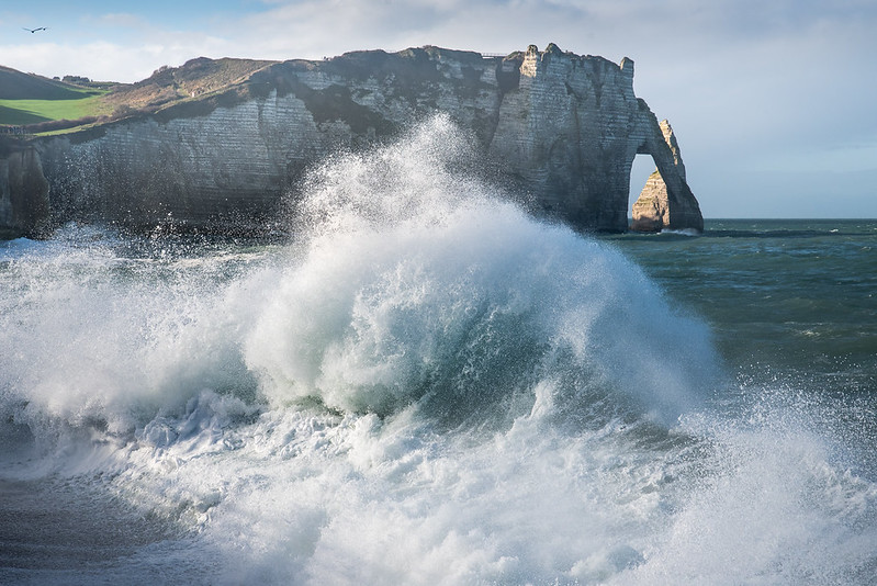
Etretat day tripm Etretat Cliffs with waves crashing in

Etretat Day Trip — Key Facts for 2026

114km from Caen · 124km from the Ouistreham ferry port · ~1h15 by car · Cliffs up to 90m high · Needle (L’Aiguille) 70m tall · Free to visit, always open

Check Ferry Prices & Book Portsmouth to Caen →

Etretat Day Trip at a Glance

114km
From Caen — around 1 hour 15 minutes by car
FREE
The cliffs, beach and town — no ticket needed to explore
90m
The height of the cliffs at their tallest points
50+
Times Claude Monet painted these cliffs, 1883–1886
  • Falaise d’Aval — the cliff with the Porte d’Aval arch and L’Aiguille needle, Monet’s favourite view. Free, always accessible
  • Falaise d’Amont — the Chapelle Notre-Dame-de-la-Garde and the Nungesser et Coli aviation memorial, with the best panoramic view over the town
  • The pebble beach — swimming is genuinely possible in summer, lifeguard-supervised, though the water stays cold
  • Le Clos Arsène Lupin — Maurice Leblanc’s own villa, now a museum dedicated to his gentleman-thief creation
  • ⚠️Always check tide times before walking beneath the cliffs. Visitors are regularly caught out and trapped by the rising tide between the headlands — this is genuine safety advice, not scaremongering

The Normandy Cliffs at Etretat

The cliffs at Etretat are the reason this small Norman fishing village became one of the most painted, photographed and written-about places on the French coast — and they’re free to walk, at any time, all year round.

What the Cliffs Actually Are

Étretat sits on the Côte d’Albâtre — the Alabaster Coast — where the chalk cliffs of the Pays de Caux meet the English Channel. Millions of years of marine and siliceous sediment, compressed into limestone and constantly worked by wind, rain and tide, have carved the coastline into three dramatic natural arches and one freestanding rock needle. British visitors often reach for the same comparison: it’s easy to think of Étretat as a French cousin of the White Cliffs of Dover, though the arches and needle here have no real English equivalent. The town itself sits in a narrow valley between two headlands: the Falaise d’Aval to the south-west and the Falaise d’Amont to the north-east, with the pebble beach and old town squeezed between them. At their highest points, the cliffs reach around 90 metres — genuinely vertigo-inducing from the clifftop paths.

This is a living, actively eroding landscape, not a static monument — cliff collapses do happen, which is exactly why staying on marked paths and away from the very edge matters here more than at most viewpoints. The Second World War left its own mark on this coastline too: German defences carved bunkers directly into the cliffs as part of the wider Atlantic Wall, and Allied bombing damaged much of the original seafront during the war — a quieter, less-visited layer of history beneath the Impressionist postcards.

⛰️ Falaise d’Aval, Porte d’Aval & L’Aiguille

On the south-west side of the beach, the Falaise d’Aval carries the most photographed view in Étretat: the Porte d’Aval, a huge natural 51 meter tall archway that Maupassant compared to an elephant dipping its trunk into the sea, standing alongside L’Aiguille — the Needle — a freestanding 70-metre spire of rock just offshore, separated from the cliff by centuries of erosion. A clifftop path (part of the golf course grounds) leads up and along for the classic postcard view back over the arch and needle together.

⛪ Falaise d’Amont, the Chapel & the Aviators

On the opposite side of the beach, the Falaise d’Amont — once known as the Falaise du Blanc-Trait for the brightness of its chalk — is reached either by a 263-step climb from the town or by driving up Avenue Damilaville. At the top: the small Chapelle Notre-Dame-de-la-Garde, dedicated to sailors and fishermen and rebuilt after WWII damage, and the striking Nungesser et Coli monument — a 24-metre concrete spire commemorating two French aviators last seen flying over these cliffs during a doomed 1927 transatlantic attempt.

🌊 La Manneporte

The largest of Étretat’s three arches, La Manneporte, isn’t visible from the town at all — you have to walk the clifftop customs path past the golf course and down to Jambourg beach to see it. Maupassant reckoned a ship could sail through it under full sail; Monet painted it too, though it’s the least visited of the three arches simply because it takes real effort to reach.

🚶 How to Visit Etretat Cliffs Safely

Stick to the marked clifftop paths and keep well back from the edge, especially in wind. If you plan to walk along the beach at the base of the cliffs — including through the small tidal cave known as the Trou à l’Homme — check tide times at the tourist office first: the sea comes in fast here, and visitors genuinely do get cut off between the headlands most years. Sturdy, grippy footwear matters more than it looks like it should; the clifftop grass gets slippery, and the beach pebbles shift underfoot.

⛵ See the Cliffs from the Water

For a genuinely different perspective, boat trips departing from nearby Fécamp (about 16km south) sail along the base of the cliffs at sea level — a roughly two-hour trip, around €33, showing you the arches and the Needle from an angle no clifftop path can match. Worth knowing before you book: the water here can be choppier than it looks from land, so it’s not the best choice if you’re prone to seasickness.

Etretat Beach: Can You Actually Swim There?

Yes — Etretat beach is a genuine, popular swimming spot, just don’t expect the Mediterranean.

🏊 What to Expect

Etretat beach is entirely pebbles, not sand — smooth, rounded shingle that’s genuinely uncomfortable to walk on barefoot for long, so bring proper sandals. Unusually for a pebble beach, the seabed itself is flat, which makes wading in and swimming easier than the shingle underfoot might suggest. The beach is supervised by lifeguards during the summer season (roughly June to September), and swimming is genuinely popular with both locals and visitors, including families.

The English Channel here stays cool even at the height of summer — water temperatures peak around 16–18°C (61–64°F) in August, and can catch out anyone expecting a warm swim. Currents can be strong, so swim within the supervised area and heed any flags or instructions from the lifeguard post. And, as with the clifftop walks, always know the tide times before you get in the water or wander along the shore — the beach narrows fast as the tide comes in.

Where to Eat

For a clifftop view with your meal, Restaurant du Golf and Le Bistrot du Dormy both sit up on the Falaise d’Aval overlooking the sea — book ahead in summer, since the view is no secret. Down in town, Le Homard Bleu is a reliable choice for fresh local seafood, fitting given Étretat’s fishing-village roots. As with most of this coastline, expect mussels, fish and seasonal Norman produce to dominate the menus.

Please Don’t Take the Pebbles

It’s tempting to pocket a smooth Étretat pebble as a souvenir, but removing stones from the beach is strictly forbidden — the shingle itself acts as the town’s natural sea defence against storm surges and erosion, and the local authority actively enforces this. Admire them, photograph them, and leave them exactly where they are.

Beyond the Cliffs: Etretat’s Literary & Artistic Past

Étretat’s fame isn’t just about geology — a handful of very different figures shaped how the world sees this small Norman town.

🎨 Monet’s Obsession with the Cliffs

Claude Monet, who grew up nearby in Le Havre, first visited Étretat in 1868 and returned repeatedly between 1883 and 1886, painting more than 50 canvases of the arches, the needle and the beach at different times of day and in different weather — an early example of the serial, light-chasing approach he’d later apply to Rouen Cathedral and his water lilies at Giverny. He stayed at the Hôtel Blanquet on the seafront, sometimes working on six canvases in a single day, chasing the light as it changed.

✍️ Guy de Maupassant’s Childhood Home

The novelist Guy de Maupassant spent much of his childhood in Étretat and built his own house here, “La Guillette,” in 1883. He wrote the town and its cliffs into several of his works — it’s Maupassant, in his novel “Une Vie,” who first described the Porte d’Amont arch as looking exactly like an elephant dipping its trunk into the Channel, a comparison every guide to the cliffs still makes today.

🗝️ Arsène Lupin & the Hollow Needle

Maurice Leblanc, creator of the gentleman-thief Arsène Lupin, lived and wrote much of the series in Étretat, and in 1909 made L’Aiguille — the Needle — the secret heart of his novel “L’Aiguille Creuse” (“The Hollow Needle”), imagining it as a legendary hideout holding the secrets of the Kings of France. Leblanc’s own villa is now Le Clos Arsène Lupin, an interactive museum, and the Netflix series “Lupin” filmed part of its first season in and around the town.

✈️ The White Bird’s Last Sighting

On 8 May 1927, French WWI flying aces Charles Nungesser and François Coli flew their biplane “L’Oiseau Blanc” (The White Bird) out over Étretat on the first leg of an attempt to make the first non-stop transatlantic flight from Paris to New York — 12 days before Charles Lindbergh’s successful crossing. It was the last confirmed sighting of the aircraft before it vanished; the two men were never found. The town’s monument on the Falaise d’Amont commemorates them.

Les Jardins d’Étretat

A genuinely striking clifftop garden, originally laid out in 1905 for the actress Madame Thébault (a friend of Monet’s) and dramatically reimagined in 2017 with sculptural, cloud-like topiary and contemporary art installations set against the cliff and sea views behind. It’s one of the few paid attractions in Étretat, and a good complement to the free clifftop walks if you want a more curated garden experience. Open April to October; check current opening hours before visiting, as the adjoining car park has had periods of closure.

How to Get to Etretat from Caen

Etretat is easiest reached by car — there’s no direct train, and public transport genuinely is a slog from this side of Normandy.

🚗 By Car — 114km, ~1h15

From Caen: cross the Pont de Normandie (toll approximately €5.90 for cars) to Honfleur, then follow the D940 north along the coast — approximately 114km, around 1 hour 15 minutes.

From the ferry port at Ouistreham: continue past Caen on the same route — approximately 124km, around 1 hour 25 minutes. Parking: the closest lot to the beach, Place du Général-de-Gaulle, is paid and fills quickly in summer; free or cheaper parking is available on the town’s outskirts, a 10–15 minute walk in. Arrive before 10am or in the evening for the best chance of a space.

🚌 Without a Car — Genuinely Difficult

There is no direct train to Étretat. The realistic public-transport route from Caen involves a train to Le Havre, then bus line 13 (roughly hourly, about an hour) or the faster seasonal Rapid’Bus 509 on to Étretat — a combined journey that can easily run to 2.5–3 hours each way. Given the distance and the connections involved, a car (your own, hired, or a guided tour) is genuinely the sensible option for this particular day trip.

How to Get from Le Havre to Etretat — And Why the Ferry Route Has Changed

Étretat is only around 32km — roughly 35 minutes by car, or about an hour by the local bus 13 — north of Le Havre, and for years that made Portsmouth to Le Havre the obvious ferry route for UK visitors heading straight to the cliffs. That’s no longer the case: Brittany Ferries has confirmed the Portsmouth to Le Havre route will end after October 2026, citing sustained low passenger numbers and rising costs.

If Le Havre was previously your route in specifically to reach Étretat, Portsmouth to Caen is now the sensible replacement. Caen runs a far more frequent service than Le Havre ever did, and while Étretat is a little further from Caen (114km) than it was from Le Havre (32km), you gain easy access to Honfleur, the D-Day beaches, Bayeux and the rest of Normandy on the same trip — genuinely useful if Étretat is one stop on a wider itinerary rather than the entire reason for the visit.

Sample Etretat Day Trip Itinerary

Étretat is compact, but the two cliffs sit on opposite sides of town — budget time to properly do both.

A Full Day at the Normandy Cliffs

Perfect for: Covering both cliffs, the town and the beach without rushing.

  • 08:30: Depart Caen early to beat the parking crush (1h15 drive)
  • 09:45: Falaise d’Amont — climb the 263 steps or drive up, visit the chapel and Nungesser et Coli monument (allow 1 hour)
  • 11:00: Back down, browse the old town and market hall
  • 12:00: Lunch by the seafront
  • 13:30: Falaise d’Aval — the Porte d’Aval, L’Aiguille and, if you have energy, the walk on to La Manneporte (allow 2 hours)
  • 15:30: Time on the beach — swim if the weather allows, or Le Clos Arsène Lupin / Les Jardins d’Étretat if you’d rather stay dry
  • 17:00: Return to Caen (1h15), or continue on to Honfleur (45 minutes south) for a coastal two-stop day

Top Tips for Your Etretat Day Trip

  • Arrive as early as you can: Étretat is genuinely one of Normandy’s most visited towns, and both parking and the clifftop paths get crowded by mid-morning in peak season.
  • Check the tide times before you go: the tourist office publishes them, and they matter for both the beach walks and the Trou à l’Homme tunnel — this isn’t optional advice, people do get caught out.
  • Bring proper shoes, not sandals: the clifftop grass can be slippery in wind and rain, and the beach pebbles are hard going in flip-flops.
  • Don’t take the pebbles home: it’s illegal and actively enforced — the shingle protects the town from storm erosion.
  • If you loved Netflix’s Lupin, book Le Clos Arsène Lupin ahead: it’s a small museum and can sell out on busy days.
  • Consider combining with Honfleur: the two sit 45 minutes apart along the same coast road, and pairing them makes for one of the best full days out on this entire site.

Etretat Day Trip: Frequently Asked Questions

How far is Etretat from Paris?

Etretat is around 206km from Paris, roughly 2.5 to 3 hours by car via the A13 motorway. By public transport, take a train from Paris Saint-Lazare to Bréauté-Beuzeville or Le Havre, then a connecting bus — the full journey typically takes around 3 hours, and seasonal direct buses (including FlixBus) also run from Paris on some days.

Can you swim at Etretat?

Yes. Etretat’s pebble beach is lifeguard-supervised in summer (roughly June to September) and swimming is genuinely popular with locals and visitors alike. The seabed is flat, making wading in easier than the shingle suggests, but the English Channel water stays cool even in August (16–18°C/61–64°F) and currents can be strong, so swim within the supervised area and always check tide times before you go in or walk the shoreline.

How do you get from Le Havre to Etretat?

Étretat is around 32km north of Le Havre, about 35 minutes by car or roughly an hour by bus line 13. However, if you’re planning your trip around the Portsmouth to Le Havre ferry, note that Brittany Ferries is ending this route after October 2026. Portsmouth to Caen is now the sensible replacement — a busier, more frequent service that also puts you within easy reach of Honfleur, the D-Day beaches and Bayeux, with Étretat around 1 hour 15 minutes further along the coast.

How do you get to Etretat?

By car is easiest — from Caen, cross the Pont de Normandie to Honfleur then follow the D940 north, around 1 hour 15 minutes. There’s no direct train to Étretat; the realistic public-transport route is a train to Le Havre or Bréauté-Beuzeville followed by a connecting bus, typically taking 2.5–3 hours from Caen or Paris. Given the distance and connections involved, a car or a guided tour is genuinely the sensible choice for most visitors.

How do you pronounce Etretat?

Etretat is pronounced roughly “ay-truh-TAH” — if you’ve searched “how to pronounce Etretat,” that’s the short answer. The emphasis falls on the final syllable, and, as with most French place names, the final “t” is silent.

How do you pronounce Etretat in French?

If you specifically want to know how to pronounce Etretat in French rather than the anglicised version, it’s roughly “ay” (as in “day,” but shorter), then a soft, almost swallowed “truh,” then a clear “tah” carrying the stress. If you’re aiming to sound natural rather than textbook-correct, listen to a native pronunciation clip before you go (Forvo.com has one) — the rhythm matters more than getting each individual sound perfect.

How do you visit Etretat cliffs?

Both cliffs are reached on foot from the town centre: the Falaise d’Aval via a path beside the golf course to the south-west, and the Falaise d’Amont via either a 263-step climb or the Avenue Damilaville road to the north-east. Both are free, open at any time, and take roughly 1–2 hours each to explore properly. Wear sturdy shoes, stay on the marked paths, keep back from the cliff edges, and check tide times before attempting any beach-level walks beneath the cliffs themselves.

Continue Planning Your Normandy Visit

Honfleur

The birthplace of Impressionism, 45 minutes south along the same coast road — pairs perfectly with Étretat

Honfleur Guide →

🏛️

Rouen

Joan of Arc, Monet’s cathedral and a magnificent medieval old town, under an hour from Étretat

Rouen Guide →

🎨

Giverny

Claude Monet’s house and water garden — see where the painter behind the Étretat canvases lived and worked

Giverny Guide →

🗺️

All Day Trips from Caen

Mont Saint-Michel, Bayeux, the D-Day beaches and more — the complete guide to exploring beyond the cliffs

Day Trips Hub →

Plan Your Etretat Day Trip — Travel via Portsmouth to Caen

Brittany Ferries sails year-round from Portsmouth to Caen (Ouistreham). From the ferry terminal, the Normandy cliffs at Etretat are around 1 hour 25 minutes by car — one of the most spectacular coastal day trips in France, and now more accessible via Caen than ever, with the Le Havre route ending after October 2026.

Check Prices & Book Portsmouth to Caen →